
Account
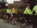
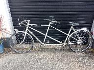
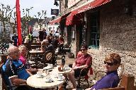
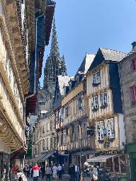
Pictures
Tandem Club GPX/TCX Rides list
 |
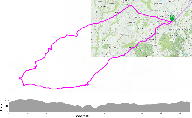
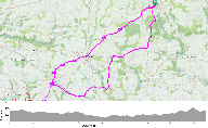
Id: 665, Quality: 4 Group: tci2023 Location: Scaer, Brittany Postcode: Scaer, Brittany Map Reference: 48.028, -3.69445 Ride length: 53 km Ride ease: Easy Added by: Phil Harmer | This route has two significant places of interest. Just outside Le Faouet there is the Sainte-Barbe chapel (15th century), built on a rock and overlooking the valley below. The return route goes via Le Saint and Guiscriff where the old station has a museum (Adult EUR6) and a cafe. |
 |
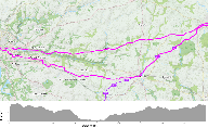
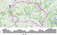
Id: 685, Quality: 3 Group: tci2023 Location: Scaer, Brittany Postcode: Scaer, Brittany Map Reference: 48.028, -3.69445 Ride length: 84 km Ride ease: Hard Added by: Phil Harmer | This takes a northerly route almost entirely on small roads into Quimper. There is lots to see in Quimper including Musee Departemental Breton, Cathedrale Saint-Corentin, Musee Des Beaux-Arts, Jardin de la Retraite, Place-Au-Beurre (Historic centre) and Halles Saint-Francois (Market). The GPX track ... |
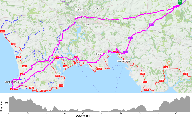 |
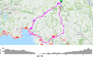
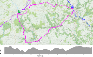
Id: 684, Quality: 2 Group: tci2023 Location: Scaer, Brittany Postcode: Scaer, Brittany Map Reference: 48.028, -3.69445 Ride length: 146 km Ride ease: Hard Added by: Phil Harmer | A long route right to the SW corner of Brittany, which the locals describe as flat? Take EV7 to Concarneau, then La Foret, Fouesnant, Benodet, Pont L'Abbe, Plomeur, Penmarc'h, to La Torche. Return is via another old railway line into Quimper and then directly through Elliant. GPX Track/Profile at ht ... |
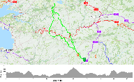 |
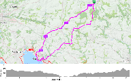
Id: 683, Quality: 2 Group: tci2023 Location: Scaer, Brittany Postcode: Scaer, Brittany Map Reference: 48.028, -3.69445 Ride length: 113 km Ride ease: Hard Added by: Phil Harmer | A long route with plenty of climbing to the site of an old Celtic temple perched on Mont Saint-Michel de Brasparts. Route out Leuhan, Laz, Saint, Thois Gouezec, Pleyben, Brasparts. Reurn Brasparts, Cloitre Pleyben and Chateauneuf de Faou, from where there is a good view of the Nantes-Brest canal. GP ... |
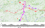 |
Id: 682, Quality: 2 Group: tci2023 Location: Scaer, Brittany Postcode: Scaer, Brittany Map Reference: 48.028, -3.69456 Ride length: 99 km Ride ease: Hard Added by: Phil Harmer | This is an extension of N-L CARHAIX via the EV7 leading to a large Sculpture park at Carnoet. It returns on the road which parallels the EV7. GPX Track/Profile at https://ridewithgps.com/routes/41963669 |
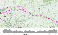 |
Id: 681, Quality: 2 Group: tci2023 Location: Scaer, Brittany Postcode: Scaer, Brittany Map Reference: 48.028, -3.69445 Ride length: 94 km Ride ease: Hard Added by: Phil Harmer | Beautiful village dating back to 6th century and renowned for producing sailcloth. Route via Coray, Langolen, Briec, Landrevarzec, Plogonnec, Back via Quemeneven to Briec to retrace route out. GPX Track/Profile at https://ridewithgps.com/routes/41963766 |
 |
Id: 680, Quality: 2 Group: tci2023 Location: Scaer, Brittany Postcode: Scaer, Brittany Map Reference: 48.028, -3.69445 Ride length: 87 km Ride ease: Hard Added by: Phil Harmer | 673 SW-L goes to Concarneau and Pont Aven. This option, suggested by the local cycling clubs, will take you to both these locations via a different route. It also offer the opportunity to see the beaches and headlands between Concarneau and Port Manec'h. 680 SW-L-3 87k NEVEZ Go south to Bannalec and ... |
 |
Id: 679, Quality: 2 Group: tci2023 Location: Scaer, Brittany Postcode: Scaer, Brittany Map Reference: 48.028, -3.69445 Ride length: 82 km Ride ease: Hard Added by: Phil Harmer | 673 SW-L goes to Concarneau and Pont Aven. This option, suggested by the local cycling clubs, will take you to both these locations via a different route. It also offer the opportunity to see the beaches and headlands between Concarneau and Port Manec'h. 679 SW-L-2 82k PENDRUC Follows EV7 to Concarn ... |
 |
Id: 678, Quality: 2 Group: tci2023 Location: Scaer, Brittany Postcode: Scaer, Brittany Map Reference: 48.028, -3.69456 Ride length: 80 km Ride ease: Hard Added by: Phil Harmer | Approximately 60% of this route is on an old railway line or the Nantes-Brest canal bank. The surface is, to our knowledge, reasonable although clearly not super fast, and reasonably flat. This follows the EV7 all the way to Carhaix Plouguer, a relatively uninspiring town, except that in cycling ter ... |
 |
Id: 677, Quality: 2 Group: tci2023 Location: Scaer, Brittany Postcode: Scaer, Brittany Map Reference: 48.028, -3.69456 Ride length: 68 km Ride ease: Average Added by: Phil Harmer | Over 60% of this route is on an old railway line or the canal bank. The surface is, to our knowledge, reasonable although clearly not super fast, and reasonably flat. It is very similar to N-L but picks up the towpath of the Nantes-Brest canal from Pont de Carhaix eastwards to Pont Triffin. It then ... |
 |
Id: 676, Quality: 2 Group: tci2023 Location: Scaer, Brittany Postcode: Scaer, Brittany Map Reference: 48.028, -3.69456 Ride length: 50 km Ride ease: Easy Added by: Phil Harmer | This route follows the EV7 north only as far as Gourin. It then heads NW to Spezet crossing the Col de Toullaeron at 266m. This climb is not particularly steep and at the top there is a Col sign so you can pose for a photograph! It returns to Scaer on quiet roads with the option of visiting the quie ... |
 |
Id: 675, Quality: 2 Group: tci2023 Location: Scaer, Brittany Postcode: Scaer, Brittany Map Reference: 48.028, -3.69445 Ride length: 72 km Ride ease: Average Added by: Phil Harmer | The route goes almost directly to Quimper entirely on small roads until you reach the outskirts of Quimper. The track at 10.3km is walkable (400m). Elliant is full of roadworks. The latest (revised) track cuts out the town centre. Between Quimper and Rosporden the track has been modified to avoid a ... |
 |
Id: 674, Quality: 2 Group: tci2023 Location: Scaer, Brittany Postcode: Scaer, Brittany Map Reference: 48.028, -3.69445 Ride length: 48 km Ride ease: Easy Added by: Phil Harmer | There are no major points of interest on this the shortest route. It picks up many quite small roads to the west of Scaer. Apart from Rosporden the towns visited are small and you should not be bothered by traffic. There's a chance of finding a really good value small restaurant but don't rely on th ... |
 |
Id: 673, Quality: 2 Group: tci2023 Location: Scaer, Brittany Postcode: Scaer, Brittany Map Reference: 48.028, -3.69445 Ride length: 80 km Ride ease: Hard Added by: Phil Harmer | The EV7 is virtually traffic free all the way to Concarneau In Concarneau allow ample time to visit la Ville Close. This is on the rocky islet of Conq that the monks of the abbey of Landevennec would have founded a priory around the 10th century. It has since been fortified by Vauban in the 17th cen ... |
 |
Id: 672, Quality: 2 Group: tci2023 Location: Scaer, Brittany Postcode: Scaer, Brittany Map Reference: 48.028, -3.69445 Ride length: 65 km Ride ease: Average Added by: Phil Harmer | The EV7 is virtually traffic free all the way to Concarneau In Concarneau allow ample time to visit la Ville Close. This is on the rocky islet of Conq that the monks of the abbey of Landevennec would have founded a priory around the 10th century. It has since been fortified by Vauban in the 17th cen ... |
 |
Id: 671, Quality: 2 Group: tci2023 Location: Scaer, Brittany Postcode: Scaer, Brittany Map Reference: 48.028, -3.69445 Ride length: 51 km Ride ease: Easy Added by: Phil Harmer | This route follows the EV7 SW for 22k and then returns via Melgven. You could stop in Rosporden where there are shops/cafes etc or picnic beside the Lake. There is also at least one bar and a Boulangerie in Melgven but it would be worth taking at least some snacks with you. It might be worth conside ... |
 |
Id: 670, Quality: 2 Group: tci2023 Location: Scaer, Brittany Postcode: Scaer, Brittany Map Reference: 48.028, -3.69445 Ride length: 82 km Ride ease: Hard Added by: Phil Harmer | This route has four significant places of interest. You will not have time to visit them all. Just beyond La Faouet there is the Cite des fourmis-Abeilles vivantes, (Adult EUR6) a zoological museum (Bees and Ants) and close by Sainte-Barbe chapel (15th century), built on a rock and overlooking the v ... |
 |
Id: 669, Quality: 2 Group: tci2023 Location: Scaer, Brittany Postcode: Scaer, Brittany Map Reference: 48.028, -3.69445 Ride length: 65 km Ride ease: Average Added by: Phil Harmer | Like SE - S, left if you like routes that are attractive and traffic free we think you will love this route, It is also relatively hilly so just take your time. The online route profile does not show any really steep climbs, but little of it is flat. Les Roches Du Diable looks a lovely place for a s ... |
 |
Id: 668, Quality: 2 Group: tci2023 Location: Scaer, Brittany Postcode: Scaer, Brittany Map Reference: 48.028, -3.69445 Ride length: 50 km Ride ease: Easy Added by: Phil Harmer | If you like routes that are attractive and traffic free we think you will love this route, It is relatively hilly so just take your time. The online route profile does not show any really steep climbs, but little of it is flat. There is one significant place of interest; the Chapelle Saint-Gilles, w ... |
 |
Id: 667, Quality: 2 Group: tci2023 Location: Scaer, Brittany Postcode: Scaer, Brittany Map Reference: 48.028, -3.69445 Ride length: 83 km Ride ease: Hard Added by: Phil Harmer | This route has four significant places of interest. You will not have time to visit them all. Just beyond La Faouet there is the Cite des fourmis-Abeilles vivantes, (Adult EUR6) a zoological museum (Bees and Ants) and close by Sainte-Barbe chapel (15th century), built on a rock and overlooking the v ... |